

December 1, 2025
Antarctica, the only uninhabited continent on the planet, has approximately 107,000 hectares of vegetation. This is revealed by the latest survey from MapBiomas, based on satellite imagery obtained over Antarctica between 2017 and 2025. Data regarding ice-free areas and those covered by vegetation during the Antarctic summer months are available for free at www.mapbiomas.org starting December 1st—Antarctica Day—, marking the anniversary of the 1959 treaty that established the continent as an international scientific research zone with the participation of 58 countries.
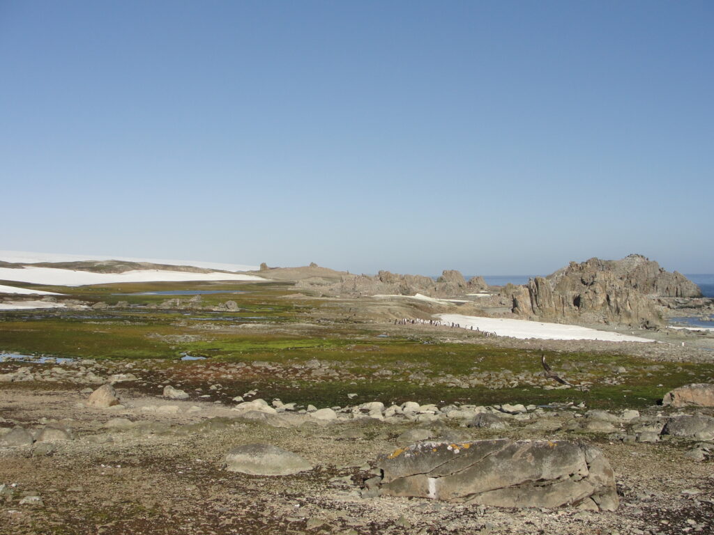
The survey shows that ice-free areas occupy 2.4 million hectares, or less than 1% of Antarctica's total area (1.366 billion hectares). Of these ice-free areas, approximately 5% are covered by vegetation, totaling just over 107,000 hectares. Vegetation in Antarctica develops in ice-free zones located primarily on islands, in coastal regions, and across the Antarctic Peninsula, but it has also been identified atop mountain ranges in the continent's interior.
"Mapping ice-free and vegetation-covered areas is crucial for monitoring the impacts of climate change on the Antarctic environment. The ice-free area map is essential for monitoring the continent's fauna, as nesting and the birth of animal species occur in these areas during the summer. The vegetation map, in turn, provides essential information to evaluate ecosystem productivity, allowing us to monitor environmental changes and sensitive regions," explains Professor Eliana Fonseca, who coordinated the mapping. "Tracking the natural dynamics of the Antarctic continent is also justified by its direct influence on the Southern Hemisphere's climate, acting as a global thermal regulator and being the birthplace of cold fronts that influence rainfall in the southern part of the Earth," the scientist adds.
Antarctica receives no solar radiation during the winter months, meaning ice-free areas can only be identified in the summer after the melting of accumulated snow and ice exposes soil and rock. Consequently, vegetation only emerges during this period in areas with higher solar incidence and on flat terrain where liquid water accumulates. With the return of winter, all this vegetation dies, leaving only spores, seeds, and vegetative structures that will sprout again the following summer in the same areas.
"The issue of solar incidence was one of the challenges of this mapping," the professor emphasizes. "Not only can we only identify ice-free areas in the summer, but during this season the phenomenon known as the ‘midnight sun’ also occurs, which is when the sun circles the continent, casting a large number of shadows created by the mountain ranges in the interior. Therefore, it was not possible to show dynamics over the years, as in other MapBiomas mappings, but rather to compose a cloud-free image mosaic with minimal shadow influence based on what the satellite captured during summer months over several years."
"This is the first version (beta) of the mapping, and we hope the next collections will involve more scientists and Antarctic research groups, bringing not only improvements in mapping ice-free and vegetated areas but also adding other variables and contributing to the monitoring and understanding of climate and environmental changes on the continent," adds Júlia Shimbo, scientific coordinator of MapBiomas.
Temperatures in Antarctica vary throughout the year and by region. While in the Antarctic islands the average monthly maximum temperature between 1958 and 2024 is positive (between 1°C and 3°C) during summer months, in the continent's interior (e.g., the Ellsworth Mountains, the highest range in Antarctica), maximum temperatures range between -15°C and -30°C, and minimums between -20°C and -35°C, remaining negative every month of the year.
Antarctic mapping on a continental scale has only recently become viable, as environmental satellites were historically designed to cover tropical and temperate regions. The MapBiomas mapping utilized Sentinel-2 satellite imagery with a 10-meter resolution, acquired between 2017 and 2025. The mapping of ice-free areas across the entire continent employed machine learning algorithms and cloud processing due to the large volume of data. Vegetation mapping was conducted through the detection of photosynthetic activity using the Normalized Difference Vegetation Index (NDVI), calculated from satellite images over the previously mapped ice-free areas.