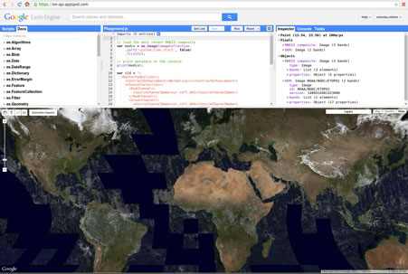
GOOGLE EARTH ENGINE
MapBiomas uses technology from the Google Earth Engine platform. We provide scripts to facilitate access to the MapBiomas collections.
To access and run follow the instructions below:
- With a Gmail account, sign up for the Google Earth Engine Platform through this link https://earthengine.google.com
- In a few days, you will receive authorization to access the platform.
- Once registered in Google Earth Engine, insert the link of the scripts you want to run.
- Change the parameters to get the map you want.
We encourage SCRIPT MAPBIOMAS users to send us their suggestions for innovation so that we can constantly improve it.
Access to MapBiomas collection on Google Earth Engine
Images and Maps collections are available to be accessed as an asset directly from Google Earth Engine, without the need to download or upload data. Here are the available products and their access IDs in Google Earth Engine:
- Land cover and use, Transition, Deforestation and Secondary Vegetation and Secondary Vegetatiton Age
projects/mapbiomas-public/assets/brazil/lulc/collection10/mapbiomas_brazil_collection10_coverage_v2 (coleção 10 )
projects/mapbiomas-public/assets/brazil/lulc/collection9/mapbiomas_collection90_transitions_v1 (coleção 9)
projects/mapbiomas-public/assets/brazil/lulc/collection10/mapbiomas_brazil_collection10_deforestation_secondary_vegetation_v2 (coleção 10)
projects/mapbiomas-public/assets/brazil/lulc/collection9/mapbiomas_collection90_secondary_vegetation_age_v1 (coleção 9 – veja de código no GEE)
- Agriculture Module (Collection 9)
projects/mapbiomas-public/assets/brazil/lulc/collection9/mapbiomas_collection90_irrigated_agriculture_v1 (veja código)
projects/mapbiomas-public/assets/brazil/lulc_10m/collection2/mapbiomas_10m_collection2_agriculture_number_cycles_v1 (código)
projects/mapbiomas-public/assets/brazil/lulc_10m/collection2/mapbiomas_10m_collection2_agriculture_mean_cycles_2017_2023_v1 (ex.)
- Mining (Industrial, Garimpo e Substância mineral princial) (coleção 10)
projects/mapbiomas-public/assets/brazil/lulc/collection10/mapbiomas_brazil_collection10_mining_substances_v3
- Pasture Module (Collection 9)
projects/mapbiomas-public/assets/brazil/lulc/collection9/mapbiomas_collection90_pasture_vigor_v1 (see GEE code example)
projects/mapbiomas-public/assets/brazil/lulc/collection9/mapbiomas_collection90_pasture_vigor_transition_v1
projects/mapbiomas-public/assets/brazil/lulc/collection9/mapbiomas_collection90_pasture_age_v1 (see GEE code example)
projects/mapbiomas-public/assets/brazil/lulc/collection9/mapbiomas_collection90_pasture_detection_year_v1 (veja exemplo de código)
projects/mapbiomas-public/assets/brazil/lulc/collection9/mapbiomas_collection90_pasture_gpp_v1 (see GEE code example)
projects/mapbiomas-public/assets/brazil/lulc/collection9/mapbiomas_collection90_pasture_last_time_mapped_v1 (veja exemplo de código)
- MapBiomas Water (collection 3)
projects/mapbiomas-public/assets/brazil/water/collection3/mapbiomas_water_annual_water_coverage_v1
projects/mapbiomas-public/assets/brazil/water/collection3/mapbiomas_water_frequency_v1
- Annual and Cumulative Burned Area and Coverage (collection 3)
projects/mapbiomas-public/assets/brazil/fire/collection3/mapbiomas_fire_collection3_annual_burned_v1
projects/mapbiomas-public/assets/brazil/fire/collection3/mapbiomas_fire_collection3_annual_burned_coverage_v1
projects/mapbiomas-public/assets/brazil/fire/collection3/mapbiomas_fire_collection3_accumulated_burned_v1
projects/mapbiomas-public/assets/brazil/fire/collection3/mapbiomas_fire_collection3_accumulated_burned_coverage_v1
- MapBiomas Fire (Collection 4)
Annual and Cumulative Burned Area and Coverage
projects/mapbiomas-public/assets/brazil/fire/collection4/mapbiomas_fire_collection4_annual_burned_v1
projects/mapbiomas-public/assets/brazil/fire/collection4/mapbiomas_fire_collection4_annual_burned_vectors_v1/mbfogo_col4_2024_v1
projects/mapbiomas-public/assets/brazil/fire/collection4/mapbiomas_fire_collection4_annual_burned_coverage_v1
projects/mapbiomas-public/assets/brazil/fire/collection4/mapbiomas_fire_collection4_accumulated_burned_v1
projects/mapbiomas-public/assets/brazil/fire/collection4/mapbiomas_fire_collection4_accumulated_burned_coverage_v1
Monthly burned area
projects/mapbiomas-public/assets/brazil/fire/collection4/mapbiomas_fire_collection4_monthly_burned_v1
Annual Burned Area by Fire Scar Size, Frequency, and Year of Last Fire
projects/mapbiomas-public/assets/brazil/fire/collection4/mapbiomas_fire_collection4_annual_burned_scar_size_range_v1
projects/mapbiomas-public/assets/brazil/fire/collection4/mapbiomas_fire_collection4_fire_frequency_v1
projects/mapbiomas-public/assets/brazil/fire/collection4/mapbiomas_fire_collection4_year_last_fire_v1
Monthly burned area (Fire Monitor)
projects/mapbiomas-public/assets/brazil/fire/monitor/mapbiomas_fire_monthly_burned_v1
- Cover and use 10 meters (beta collection)
projects/mapbiomas-public/assets/brazil/lulc/collection_S2_beta/collection_LULC_S2_beta (see GEE code example)
- Soil (coleção 2 beta)
Soil Organic Carbon Stock
projects/mapbiomas-public/assets/brazil/soil/collection2/mapbiomas_soil_collection2_soc_kgc_m2_000_030cm
projects/mapbiomas-public/assets/brazil/soil/collection2/mapbiomas_soil_collection2_soc_tc_ha_000_030cm
projects/mapbiomas-public/assets/brazil/soil/collection2/mapbiomas_soil_collection2_soc_tc_ha_000_030cm_coverage
projects/mapbiomas-public/assets/brazil/soil/collection2/mapbiomas_soil_collection2_socsoc_tc_ha_000_030cm_coverage
Soil Texture
projects/mapbiomas-public/assets/brazil/soil/collection2/mapbiomas_soil_collection2_granulometry_clay_percentage
projects/mapbiomas-public/assets/brazil/soil/collection2/mapbiomas_soil_collection2_granulometry_sand_percentage
projects/mapbiomas-public/assets/brazil/soil/collection2/mapbiomas_soil_collection2_granulometry_silt_percentage
projects/mapbiomas-public/assets/brazil/soil/collection2/mapbiomas_soil_collection2_textural_classes
projects/mapbiomas-public/assets/brazil/soil/collection2/mapbiomas_soil_collection2_textural_groups
projects/mapbiomas-public/assets/brazil/soil/collection2/mapbiomas_soil_collection2_textural_subgroups
projects/mapbiomas-public/assets/brazil/soil/collection2/mapbiomas_soil_collection2_textural_triangule
Landsat Imagery Mosaic for each year of Collection 8 10
ID: projects/nexgenmap/MapBiomas2/LANDSAT/BRAZIL/mosaics-2
PLUGIN FOR QGIS
MapBiomas map collections are available directly in QGIS through the MapBiomas Plugin.
Access directly in QGis via the plugin: (We are also preparing one for ArcGIS).
See the instructions for installing and using the MapBiomas Plugin here.
GITHUB
MapBiomas Processing Codes Depository
The codes used by MapBiomas to produce maps including classification, spatial and temporal filters, data integration, generation of transitions and calculation of statistics, among others, are available in the MapBiomas code repository on GitHub.
Acesso em: https://github.com/mapbiomas/brazil-all-initiatives
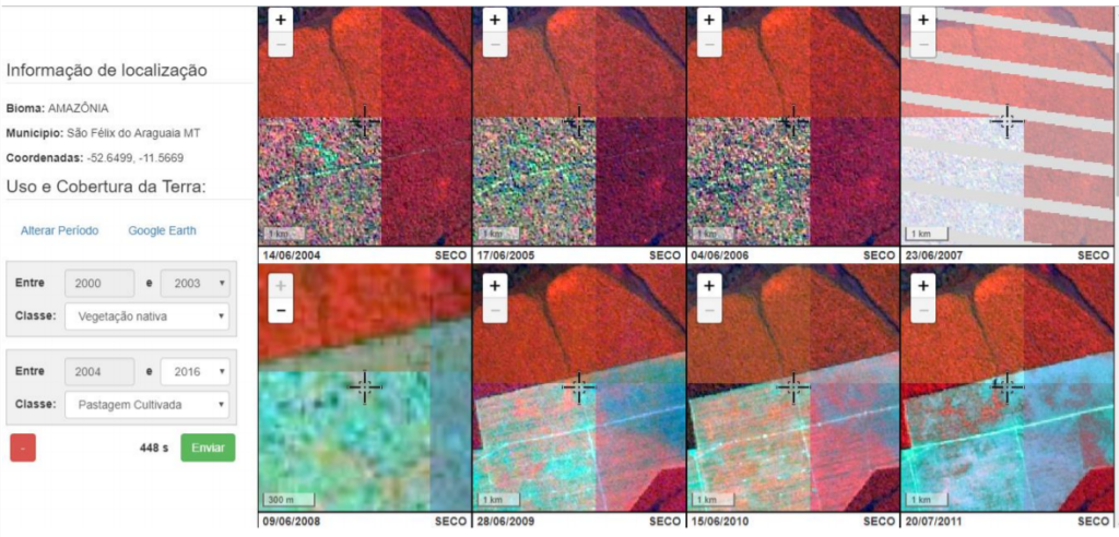
TVI (TEMPORAL VISUAL INSPECTION)
Open source online tool for visual inspection of sample points in historical Landsat satellite remote sensing image series. Created by the Image Processing Laboratory of the Federal University of Goiás (LAPIG - UFG), TVI provides subsidies that facilitate and streamline the process of interpreting satellite series for the training and calibration of image classification algorithms. In MapBiomas, TVI was mainly used to obtain validation points of the annual pasture area distribution mappings in the Brazilian territory.