

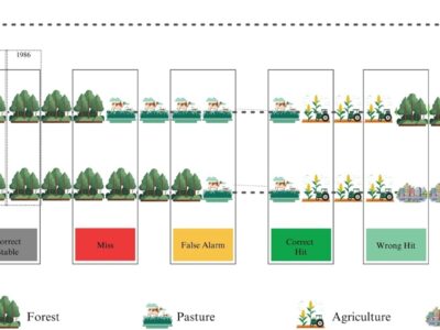
Matos et al – Accounting for alternation in temporal quality analysis in MapBiomas Brazil
Land use and land cover maps are an important resource for understanding the interactions between humans and their environment in space and time, with current mapping efforts typically spanning more than 20 years. We present here a new method for a robust evaluation of land cover transitions over time and apply this methodology to the annual land use maps of MapBiomas in Brazil, from 1985 to 2022. Based on a reference sample of 85,152 points, we found that MapBiomas has limited accuracy as an indicator of annual land use change, but is consistent throughout the mapping period. Alternation, a newly defined error component, captures the number of land use transitions a location experiences over time. This is the main reason for the differences in annual change estimates and is 4.6 times more frequent in the MapBiomas product than in the reference data. Differences in alternations are particularly predominant in transitions from pasture to savanna and forest classes. The total land use changes detected during the 37-year study period are consistent between the reference data and the MapBiomas classification, with 232 million hectares and 252 million hectares, or 27% and 29% of the Brazilian territory, respectively.
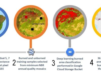
Rocha et al – Mapping Burned Area in the Caatinga Biome: Employing Deep Learning Techniques
The semi-arid Caatinga biome is particularly susceptible to fire dynamics. Periodic droughts amplify the risk of fire, while anthropogenic activities, such as agriculture, pasture expansion, and deforestation, contribute significantly to the prevalence of fires. This research aims to evaluate the effectiveness of a fire detection model and analyze the spatial and temporal patterns of burned areas, providing essential insights for fire management and prevention strategies. Using Deep Neural Network (DNN) models, we mapped burned areas across the entire Caatinga biome from 1985 to 2023, based on annual quality mosaics derived from Landsat and minimum NBR values. Over the 38-year period, the model classified 10.9 Mha (12.7% of the Caatinga) as burned, with an average annual burned area of approximately 0.5 Mha (0.56%). The peak burned area reached 0.89 Mha in 2021. Fire scars varied significantly, ranging from 0.18 Mha in 1985 to substantial fluctuations in subsequent years. The most affected vegetation type was savanna, with 9.8 Mha burned, while forests suffered only 0.28 Mha of burns. October emerged as the month with the highest fire activity, accounting for 7266 hectares. These findings underscore the complex interaction of climatic and anthropogenic factors, highlighting the urgent need for effective fire management strategies.
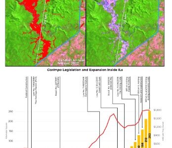
Ferreira Neto et al – Uncontrolled Illegal Mining and Garimpo inthe Brazilian Amazon
Mining has played an important role in the economies of South Americancountries. Although industrial mining prevails in most countries, the expan-sion of garimpo activity has increased substantially. Recently, Brazil exhibitedtwo moments of garimpo dominance over industrial mining: 1989–1997 and2019–2022. While industrial mining sites occupied ~ 360 km2 in 1985 butincreased to 1800 km2 in 2022, a 5-fold increase, garimpo mining areaincreased by ~ 1200%, from ~ 218 km2 in 1985 to ~ 2627 km2 in 2022. More than91% of this activity is concentrated in the Amazon. Where almost 40% of thesites are five years old or younger, this proportion increases to 62% withinIndigenous lands (ILs). Regarding the legal aspect, at least 77% of the 2022extraction sites showed explicit signs of illegality. Particular attention must begiven to the Kayapo, Munduruku, and Yanomami ILs. Together, they con-centrate over 90% of the garimpo across ILs.

Souza et al – Amazon severe drought in 2023 triggered surface water loss
The work aims to present an estimate of the extent of water loss in the Brazilian Amazon in 2023, due to the severe drought caused by El Niño and ocean warming. The research estimates a loss of 3.3 million hectares of surface water, highlighting the most affected areas, especially in the states of Amazonas and Pará, and the significant impacts on rivers and aquatic biodiversity. Furthermore, it assesses how this loss affects traditional communities, such as indigenous people and extractivists, and emphasizes the vulnerability of these populations to climate change. Finally, the article advocates for the creation of an integrated monitoring system to improve the understanding of climatic impacts and facilitate an adequate response to these issues.
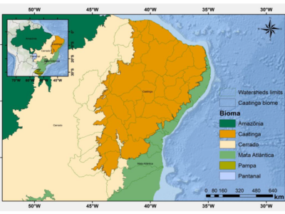
Rocha et al – Towards Uncovering Three Decades of LULC in the Brazilian Drylands: Caatinga Biome Dynamics (1985–2019)
This article aims to analyze changes in land use and land cover in the Caatinga biome in Brazil over a span of 35 years, from 1985 to 2019. Through a collaboration with the MapBiomas project and utilizing Landsat data, the study provides a detailed view of the transformations in the Caatinga landscape. The results highlight a significant reduction in natural vegetation, mainly due to the expansion of cattle ranching and agriculture, and underscore the importance of understanding these changes for the development of social, economic, and environmental policies for the region and other dryland areas around the world.
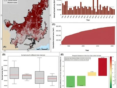
Arruda et al – Assessing four decades of fire behavior dynamics in the Cerrado biome (1985 to 2022)
This article analyzes four decades of fire data in the Brazilian Cerrado (1985–2022) using annual fire maps. The study reveals that 40% of the biome has been affected by fires, with an increase in both the frequency and size of burned areas, primarily due to human ignitions and agricultural expansion. The article also highlights the need for conservation strategies, such as Integrated Fire Management, to mitigate these impacts and enhance climate resilience.
Souza et al – Landsat sub-pixel land cover dynamics in the Brazilian Amazon
This study proposes a novel approach to characterize and measure land cover dynamics in the Amazon biome. First, we defined 10 fundamental land cover classes: forest, flooded forest, shrubland, natural grassland, pastureland, cropland, outcrop, bare and impervious, wetland, and water. Second, we mapped the land cover based on the compositional abundance of Landsat sub-pixel information that makes up these land cover classes: green vegetation (GV), non-photosynthetic vegetation, soil, and shade. Third, we processed all Landsat scenes with <50% cloud cover. Then, we applied a step-wise random forest machine learning algorithm and empirical decision rules to classify intra-annual and annual land cover classes between 1985 and 2022. Finally, we estimated the yearly land cover changes in forested and non-forested ecosystems and characterized the major change drivers.
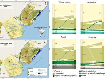
Baeza et al – Two decades of land cover mapping in the Río de la Plata grassland region: The MapBiomas Pampa initiative
This work describes and analyzes the land cover changes in the entire Río de la Plata Grasslands (RPG) region for the first two decades of the 21st century, especially those related to grassland loss. In 20 years, RPG region lost, at least, 2.4 million ha of grassland (9% of the remaining grassland area in 2001). Most of these losses are concentrated in Brazil and Uruguay and are associated with new agricultural or forestry areas that increased by 5% and 100%, respectively.
Alencar et al – Long-Term Landsat-Based Monthly Burned Area Dataset for the Brazilian Biomes Using Deep Learning
The paper presents a new strategy using machine learning to map monthly burned areas from 1985 to 2020 using Landsat image mosaics and minimum NBR values. This new dataset contributes to the understanding of the long-term spatial and temporal dynamics of fire regimes that are fundamental to designing appropriate public policies to reduce and control fires in Brazil.
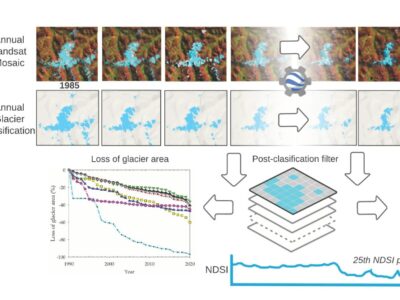
Cayo et al – Mapping Three Decades of Changes in the Tropical Andean Glaciers Using Landsat Data Processed in the Earth Engine.
This paper presents the mapping and retreat dynamics of tropical Andean glaciers (TAGs) from the use of Landsat time series images from 1985 to 2020, with digital processing and classification of the satellite images on the Google Earth Engine platform.