

September 18, 2025
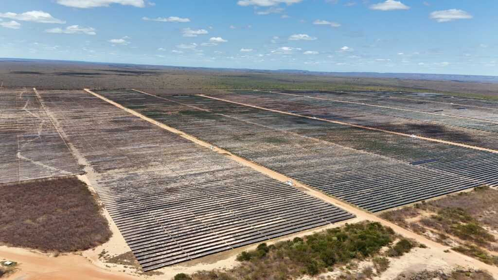
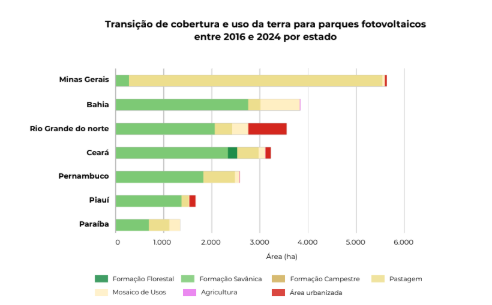
The Caatinga, an exclusively Brazilian biome, is emerging as a protagonist in the country's energy transition, housing 62% of Brazil's photovoltaic power plant areas, which totaled 35,300 hectares nationwide in 2024. The advancement of solar plants in the Caatinga reflects the region's solar potential, with 21,800 hectares of the biome already occupied by these installations. Of this total within the biome, 26% (5,600 ha) are located in Minas Gerais. Most of the area converted for photovoltaic power plants (52.6%, or 11,400 ha) was previously savanna and forest formations, while 35% (7,500 ha) were pastures.
"This transition, while contributing to the country's clean energy matrix, raises questions about this recent land use in Brazil and the conservation of native vegetation in the Caatinga," comments Professor Washington Rocha, coordinator of the MapBiomas Caatinga team.
The data comes from a detailed survey of changes in land cover and land use in the Caatinga, based on MapBiomas Collection 10 of land cover and land use maps, covering the period between 1985 and 2024. The report reveals that the biome, which occupies 86.2 million hectares (10.1% of Brazil's territory), has suffered a loss of 9.25 million hectares of natural areas over the last 40 years—equivalent to 14% of its original cover—with the expansion of farming and ranching as the primary driver of transformation.
In 2024, nearly two-thirds (59%, or 51.3 million hectares) of the Caatinga are still covered by native vegetation, predominantly savanna formations (55.9%). When accounting for water bodies, beaches, dunes, and sandy areas, the Caatinga's natural area rises to 52.9 million hectares, or 61% of the biome. Among natural area types, savanna formations were the most affected, losing 8.9 million hectares (15.7%) during the perio
The anthropic area in the Caatinga increased by 39% between 1985 and 2024, totaling an expansion of 9.2 million hectares. More than one-third (37%, or 32.3 million hectares) of the biome is occupied by agricultural and livestock areas. Pasture is the main anthropic use, accounting for 24.7% of the biome's total and expanding by 106% (11 million hectares) since 1985. Proportionally, agriculture was the fastest-growing land use, with a 1,636% increase (1.7 million hectares) in the same period. Among agricultural uses, temporary crops predominate with 1.4 million hectares (74%), while perennial crops occupy 483,000 hectares (26%).
This expansion occurred primarily over savanna formations, which are also the natural cover class most affected by fires annually, accounting for an average of 78% of occurrences. Over the last 40 years, 11.4 million hectares of the Caatinga have been burned—an area larger than the territory of Portugal.
Between 1985 and 2024, the Caatinga lost 66,000 hectares (21%) of its natural water surface. Water surface in the biome is predominantly found in hydroelectric plants, which occupy about 390,000 hectares (42%), mostly in the São Francisco River basin (96% or 375,000 ha). Reservoirs account for 32% of the water surface area in the biome (297,000 hectares).
Every state in the biome recorded a reduction in natural areas during this period, with 86% (1,042) of Caatinga municipalities showing a loss of native vegetation. Despite this, 55% (670) of the municipalities still have more than 50% native vegetation. The states with the highest proportion of natural areas in 2024 are Piauí (82%), Ceará (68%), Pernambuco (60%), Bahia (58%), and Paraíba (56%). The states with the lowest proportion of natural areas last year were Minas Gerais (50%), Rio Grande do Norte (50%), Alagoas (27%), and Sergipe (24%).
One-tenth (10%) of the Caatinga territory is protected by Conservation Units (8.2 million hectares), which house 13% of the biome's native vegetation (6.8 million hectares) as of 2024. Three out of every four hectares of Conservation Units in the Caatinga are Sustainable Use Conservation Units (6.1 million hectares). In these areas, there was an 11.8% reduction in native vegetation area between 1985 and 2024 (-563,000 hectares).