

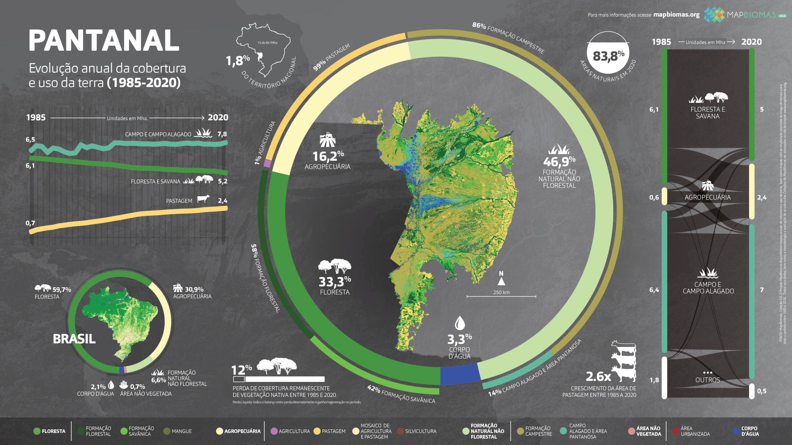
The largest wetland on the planet is getting drier. The difference between the total area covered by water and flooded fields recorded during the flood of 1988/1989 and that of 2018 is 29%. In the first flood recorded in the historical series of satellite images analyzed by MapBiomas, this total was 5.9 million hectares. In the last one, in 2018, the area reached only 4.1 million hectares. In 2020, this value was 1.5 million hectares, the lowest in the last 36 years. These and other data were presented in a webinar on Wednesday, September 29th, on the MapBiomas YouTube channel.
Drier, the Pantanal is also more susceptible to fire. Wet periods favor the development of herbaceous, shrubby, aquatic, and semi-aquatic plants, accumulating biomass. During the dry season, the dry vegetation becomes fuel for fire. Of all Brazilian biomes, the Pantanal was the most burned in the last 36 years: 57% of its territory was burned at least once during this period, totaling 86,403 km². Grassland and savanna vegetation areas were the most affected, accounting for over 75% of the burned areas. In total, 93% of fires in the period occurred in native vegetation; only 7% occurred in anthropogenic areas. In 2020, over 2.3 million hectares were burned, and since 1985, this figure has only been lower than the burned area in 1999, with 2.5 million hectares.
"The conservation of the Pantanal, its culture, and traditional use depend on the flood cycles and the rivers that originate in the Plateau region, where the headwaters of the Upper Paraguay Basin are located," explains Eduardo Rosa from MapBiomas. While 83.8% of the plain was covered by native vegetation in 2020, in the plateau, this occurred in only 43.4% of the territory. Degraded pastures, the lack of forests that protect springs and rivers, the construction of hydroelectric plants, affect the flow of rivers, which also suffer from sediment deposition that reduces water flow, both in the plateau and in the plain."
Anthropogenic use in the Pantanal increased by 261% between 1985 and 2020, gaining 1.8 million hectares. During this period, the area of pastures in the Upper Paraguay Basin doubled, from 15.9% in 1985 to 30.9% in 2020. Agriculture, on the other hand, quadrupled, from 1.2% in 1985 to 4.9% in 2020. Meanwhile, savanna formation decreased from 24.4% in 1985 to 18% in 2020. In 2020, 40% of the Upper Paraguay Basin is under agricultural use.
About MapBiomas
MapBiomas is a multi-institutional initiative that brings together universities, NGOs, and technology companies that have joined forces to contribute to the understanding of the transformations of the Brazilian territory through annual mapping of land use and land cover in Brazil. In August 2021, MapBiomas Collection 6 was published with maps of land cover and land use in Brazil from 1985 to 2020. The tool developed by MapBiomas for all its initiatives provides information generated with a spatial resolution of 30 meters. The data are processed using automatic classification algorithms through information in the Google Earth Engine cloud.
Access the main highlights of the Pantanal biome.

Download the infographics of the biomes here.
Learn how the webinar for presenting the data went: