

New survey from MapBiomas details agribusiness in Brazil
December 10, 2025
Agricultural activities occupy 32% of Brazilian territory, with more than half of this area (56.7%) consisting of planted pastures and 23% dedicated to agriculture. In both cases, satellite imagery indicates an intensification of land use: nearly two-thirds (64%, or 31.4 million hectares) of the area occupied by temporary crops—such as soy, corn, or cotton—showed more than one cycle, which may consist of another crop or cover plants; and more than three out of every four hectares of pasture (78%, or 121.4 million hectares) have medium or high vigor—a condition that allows for raising a greater number of animals per hectare. These are some of the figures released by MapBiomas this Wednesday, December 10, which are already available for free on the platform https://brasil.mapbiomas.org
MapBiomas is launching its first version of the second-crop agriculture maps –agricultural crops planted after summer harvest of temporary crops. It adds information to the "number of cycles" map launched last year and aims to identify the specific crop planted after the harvest of the first-crop cycles already mapped by MapBiomas. Still in beta version, it covers only data between 2000 and 2024 and the states with the largest production areas of second-crop corn and cotton, presenting three classes: corn, cotton, and other temporary second crops or cover crops.
The mapping indicates that corn is the main second crop in Brazil. In 2024, 14.7 million hectares of corn were identified in the second crop, along with 2.5 million hectares of cotton and 6.5 million hectares of other temporary crops or cover species. About 95% of the second-crop corn fields mapped by MapBiomas were planted after the soybean harvest.
“The second crop is an asset of tropical agriculture in grain production. It increases the economic return for the producer and assists in the conservation of native vegetation, as it allows for increased production without clearing new areas. Additionally, it utilizes nutrients from the previous crop and raises the potential for carbon sequestration. Corn, in particular, leaves behind abundant straw after harvest, which is fundamental for soil and water conservation and for carbon fixation in the soil via no-till farming. However, the expansion of the second crop also faces challenges. One is soil degradation due to more intensive use, requiring special attention to management practices. There is also the climate, with a trend of reduced rainfall and a lengthening of the dry season, which could make the second crop unfeasible in the future, especially for corn,” highlights Professor Eliseu Weber, one of the coordinators of the agriculture theme at MapBiomas.
Regarding the states, the mapping identified that in 2024, 7.1 million hectares of corn (48% of the total mapped) and 1.6 million hectares of cotton were cultivated in the second crop in Mato Grosso. Paraná showed a total of 5 million hectares planted with a second crop, with 2.2 million hectares of corn and 2.8 million hectares of another second crop or cover crop. In Mato Grosso do Sul, the second crop occupied 2 million hectares, with 1.9 million hectares of corn and 100,000 hectares of cotton. Goiás showed similar numbers: 2 million hectares cultivated in the second crop, with 1.7 million hectares of corn and 300,000 hectares of cotton.
In the case of the summer harvest, soybean cultivation grew from 4.5 million hectares mapped in 1985 to 40.7 million hectares mapped in 2024. Nearly two-thirds (65%) of the agriculture mapped in Brazil in 2024 corresponds to first-crop soybean fields. More than two-thirds (65%) of the area mapped as first-crop soy in 2024 showed two cultivation cycles (26.3 million hectares) and 6.1% showed three cycles (2.5 million hectares). Nearly a quarter of the total (21%) showed only one cycle (8.6 million hectares)
In 2024, following the soybean harvest, 14 million hectares of corn, 2.4 million hectares of cotton, and 6 million hectares of other temporary crops were cultivated. The largest area with this dynamic is in Mato Grosso, where 6.7 million hectares of corn are cultivated after the soybean harvest. This means that 94% of the total corn in the state is grown in succession to the soybean crop in the summer harvest. In second place is Paraná (2.2 million hectares), followed by Mato Grosso do Sul (1.8 million hectares).
“The mapping of the main second crops in Brazil represents an advancement in understanding the use of the country's agricultural areas, and its release by MapBiomas marks an important step in overcoming the challenges associated with this type of monitoring. Due to Brazil's territorial extent and climatic diversity, the same crop presents different agricultural calendars across states, which required the development of a methodology capable of functioning consistently in different regional contexts. This process involved detailed analysis of the agricultural dynamics of each state and the manual and systematic collection of samples over time. The results achieved show strong alignment with area estimates released by official sources, such as Conab, but we still have challenges in mapping important states like Santa Catarina and Rio Grande do Sul,” details Kenia Mourão, one of the Agriculture coordinators at MapBiomas.
Sugarcane areas were also mapped, growing from 2.2 million hectares in 1985 to 10.1 million hectares in 2024. Areas mapped with rice grew from 390,000 hectares in 1985 to 1.1 million hectares in 2024. In the case of citrus, the increase was from 100,000 hectares in 1985 to 400,000 in 2024. Oil palm also saw significant growth, going from 10,000 hectares mapped in 1985 to 240,000 hectares in 2024, with this growth concentrated in the state of Pará. Areas occupied by silviculture (forestry) grew from 1.56 million hectares in 1985 to 9 million hectares in 2024.
The expansion of agricultural activity in Brazil occurred mainly over pasture areas. Meanwhile, the expansion of pasture areas has occurred predominantly over native vegetation, especially forest formations, followed by savanna formations—a pattern that can be observed across all analyzed decades. However, the data indicates that many pasture areas returned to native vegetation classes over the decades, especially savanna formations. This included 1.4 million hectares from 1985 to 1994, 3.5 million hectares from 1995 to 2004, 3.9 million hectares from 2005 to 2014, and 4.9 million hectares from 2015 to 2024.
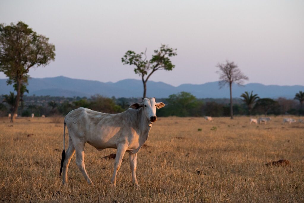
Although half (about 77.8 million hectares) of Brazilian pastures are more than 30 years old and one-third of the total has existed since 1985, vigor conditions show a prevalence of pastures with low biological degradation, related to the levels of exposed soil. Only one-fifth of the area mapped as pasture (21.6%, or 33.4 million hectares) shows signs of low vigor—that is, pastures with low forage production and a high presence of exposed soil throughout the year. The majority falls between medium (43%, or 66.6 million hectares) and high vigor (35.4%, or 54.8 million hectares).
From 2000 to 2024, pastures recorded a net gain in vigor of 6.2 million hectares: in 20.8 million hectares, vigor increased, and in 14.6 million hectares, it decreased. From 2000 to 2024, 62 million hectares showed no change in vigor, and 11.1 million hectares evolved to high-vigor status.
Another indicator of the pasture's capacity to feed livestock is biomass production—the amount of plant matter produced. The higher the available biomass, the greater the carrying capacity of the pasture. In 2024, Brazilian pastures produced approximately 3.63 gigatons of biomass/forage. The Amazon is the biome with the highest pasture biomass productivity, with values above 25 tons/ha/year. In the Cerrado and Pantanal, pastures present a predominant biomass in the range of 15 to 20 tons/ha/year. In the Caatinga, pastures exhibit even lower productivity, generally below 15 tons/ha/year. The biomass of pastures in the Atlantic Forest shows greater variation across the biome, with values fluctuating between 10 and 25 tons/ha/year.
“Despite the good indicators of vigor and forage production in Brazilian pastures, the nearly 22% of planted pastures mapped as having low vigor in 2024 suggest a condition of severe degradation. This area, which corresponds to approximately 34 million hectares, represents an enormous opportunity as a land reserve for other uses, in convergence with the National Program for the Conversion of Degraded Pastures implemented by the federal government,” highlights Professor Laerte Guimarães Ferreira, coordinator of the Pasture theme at MapBiomas.
The states of Pará (21.7 million hectares), Mato Grosso (20.2 million hectares), Minas Gerais (19.3 million hectares), Bahia (14.6 million hectares), Mato Grosso do Sul (12.2 million hectares), and Goiás (12 million hectares) hold 69.8% of the 155 million hectares occupied by pastures throughout Brazil.