

THE FIRST EDITION EMPHASIZED THE IMPORTANCE OF RESEARCH ON SOIL USE AND ITS RELATIONSHIP WITH INFRASTRUCTURE IN BRAZIL
The objective of the 1st Edition of the MapBiomas Award was to stimulate studies on the relationship between energy and transport infrastructure and the dynamics of changes in land cover and land use in Brazil.
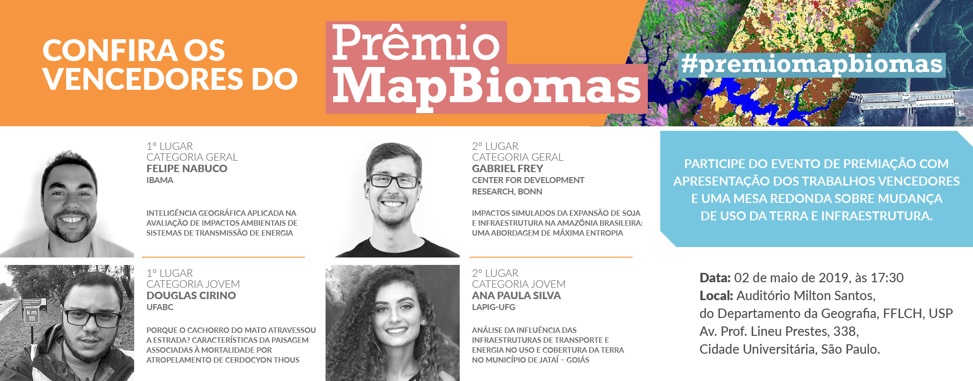
The works came from 11 states of Brazil (GO, SP, MG, BA, RJ, PE, CE, RS, PA, AM, DF) and also from Germany. Another point registered was the gender indicator, which showed a balance with 53% of men and 47% of women among the enrolled. The works compete in the categories of Youth and General. The awards event took place on May 2nd, 2019 at the Milton Santos Auditorium of the USP Department of Geography.
THE WINNERS
In the General Category, one of the topics raised was the challenges associated with the expansion of the power transmission network in Brazil and how we can improve the Environmental Impact Assessment (EIA) of Power Transmission Systems. Felipe Nabuco's work from IBAMA, co-authored with Rodrigo Nóbrega from UFMG, was awarded first and uses MapBiomas land use data in spatial modeling to support environmental licensing analysis. In addition, it pointed to greater transparency of the agency in the conduct of processes and in the definition of the terms of reference issued for the purposes of environmental licensing of Power Transmission Systems. Thus, IBAMA technical teams can better qualify information and environmental licensing assessments in the electricity sector. (Access the work)
In second place in this category, the award was given to the work that analyzed the possible impacts of soy and infrastructure expansion in the Brazilian Amazon. The expansion of soybean cultivation has been one of the main direct or indirect vectors of farming expansion over areas of native vegetation in Brazil, especially in the Cerrado and Amazon. Gabriel Frey, in partnership with other researchers from the Center for Development Research, Bonn (Germany), developed a model to identify areas at high risk of soy expansion, thus assisting conservation efforts in the region. In addition to the nearly 3,000 hectares of soybeans planted in the Legal Amazon in 2014, the research identified another 14,000 ha that could be threatened by this conversion. By simulating how potential future improvements in infrastructure would affect the probabilities of soy occurrence in the region, it was found that infrastructure improvement can increase by 14.6% in the areas at risk of soy expansion. If this occurs in practice, at least 4.8 Pg of CO2 could be released into the atmosphere, a value that represents 10 times the total CO2 emissions from Brazil in 2014. (Access the work)
In the Youth category, firstly was awarded the work of Douglas Cirino and his colleagues at the Federal University of ABC (UFABC), which addressed how roadkills of the Cerdocyon thous (bush dog) species can be related to changes in land cover and use. Present in most of South America and in all Brazilian biomes, except the central Amazon, it is one of the species with the largest roadkill in Brazil. Through a landscape analysis using MapBiomas land use and land cover maps and georeferenced animal mortality data on Brazilian highways, the authors concluded that the presence of roads can cause agricultural use to advance in areas where there was native vegetation and This conversion leads individuals of the Cerdocyon thous species to follow the expansion in a risky manner for the continuity of the species. The results indicate that most of these species are run over in the vicinity of rivers and water bodies and in large areas of land converted into agriculture. (Access the work)
For second place in the Youth Category, Ana Paula M. Silvia, co-authored by Pâmela Assis, from the Federal University of Goiás - UFG, analyzed the influence of transport and energy infrastructures on land use and coverage in the municipality of Jataí, The municipality has had major changes in the landscape since the 80's with the expansion of the agricultural frontier. The analysis identified that with the increase of agribusiness, mainly in commodities, the locality has been receiving investments in infrastructure works such as increase and improvement in federal and state highways, implementation of power substation and transmission lines, as well as small hydroelectric plants, aerodromes. and ethanol plant. Investments, in turn, influenced an increase of 16% in areas destined for annual and perennial agriculture, in addition to the emergence of areas for mining and cultivation of sugarcane. At the same time, the native vegetation area that covered 35% of the municipality in 1985 was reduced to 24% in 2017. (Access the work)
The works indicate a variety of land use and coverage data applications and their relationships with infrastructure works in Brazil. Ranging from academic research with historical analysis and modeling of future scenarios, to practical actions by government agencies related to territorial planning to environmental licensing of energy and transport infrastructure works.
1ST EDITION MAPBIOMAS AWARDS
This is the first edition of the MapBiomas Prize that has as a premise for registrants the use of the historical land use and land cover series in Brazil available on the MapBiomas platform, where it is possible to analyze land cover and land use data by various territorial clippings. such as states, biomes, municipalities, watersheds, and protected areas, as well as energy and transportation infrastructure data.
Registration ended on January 31, 2019.
AWARD INSTRUCTIONS (ONLY IN PORTUGUESE) FAQ (ONLY IN PORTUGUESE)
For more information about the MapBiomas Award visit the website - www.brasil.mapbiomas.org/premio
Questions and clarifications via e-mail - premio@mapbiomas.org
Find out more about other editions