

Parente et al – Next Generation Mapping: Combining Deep Learning, Cloud Computing, and Big Remote Sensing Data.
This study evaluated, based on thousands of PlanetScope images obtained over a 12-month period, the performance of three machine learning approaches (random forest, long short-term memory - LSTM, and U-Net). We applied these approaches to mapped pasturelands in a Central region in Brazil.
Parente et al – Assessing the pasturelands and livestock dynamics in Brazil, from 1985 to 2017: A novel approach based on high spatial resolution imagery and Google Earth Engine cloud computing.
This work mapped, annually and in an unprecedented way, the totality of the Brazilian pastures, from 1985 to 2017. With an overall accuracy of about 90%, the 33 maps produced indicated the pasture area varying from ~118 Mha ±2.53% (2017), with this expansion occurring mostly in the northern region of the country and to a lesser extent in the midwest.
Diniz et al. – Brazilian Mangrove Status: Three Decades of SatelliteData Analysis.
This manuscript presents a Google Earth Engine (GEE) managed pipeline to compute the annual status of Brazilian mangroves from 1985 to 2018, along with a new spectral index, the Modular Mangrove Recognition Index (MMRI), which has been specifically designed to better discriminate mangrove forests from the surrounding vegetation. If compared separately, the periods from 1985 to 1998, and 1999 to 2018 show distinct mangrove area trends.
Souza, Jr. et al – Long-Term Annual Surface Water Change in the Brazilian Amazon Biome: Potential Links with Deforestation, Infrastructure Development and Climate Change.
In this study, we present a long-term spatiotemporal analysis of surface water annual change and address potential connections with deforestation, infrastructure expansion, and climate change in this region.
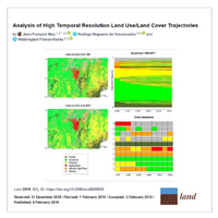
Mas et al – Analysis of High Temporal Resolution Land Use/Land Cover Trajectories.
In this study, methods, originally developed to assess life course trajectories, are explored in order to evaluate land change through the analysis of sequences of land use/cover. Annual land cover maps that describe land use/land cover change for the 1985-2017 period for a large region in Northeast Brazil were analyzed.
Costa et al – Novas tecnologias e sensoriamento remoto: aplicação de uma oficina didática para a disseminação das potencialidades dos produtos e ferramentas do MapBiomas.
This work aimed to report the experiences of the application of a didactic workshop that dealt with the potential of the products and tools of the MapBiomas Project in a class of the Graduate Program in Earth and Environmental Science Modeling, from the State University of Feira de Santana.
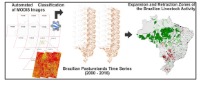
Leandro Parente & Laerte Ferreira – Assessing the Spatial and Occupation Dynamics of the Brazilian Pasturelands Based on the Automated Classification of MODIS Images from 2000 to 2016.
This study mapped, through objective criteria and automatic classification methods (Random Forest) applied to MODIS (Moderate Resolution Imaging Spectroradiometer) images, the totality of the Brazilian pastures between 2000 and 2016.
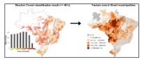
Parente et al. – Monitoring the brazilian pasturelands: A new mapping approach based on the landsat 8 spectral and temporal domains.
In this study, we utilized the entire set of Landsat 8 images available for Brazil in 2015, from which dozens of seasonal metrics were derived, to produce, through objective criteria and automated classification strategies, a new pasture map for the country.
Rosa, Marcos R – Comparação e análise de diferentes metodologias de mapeamento da cobertura florestal da Mata Atlântica.
The differences found in the products point to distinct and complementary uses, with the Atlas base most suitable for identifying deforestation and analyzing biodiversity conservation, and MapBiomas for analysis of fragmentation, restoration, and water protection. The options for the product that will be used vary according to the objective of the proposed work.