

11 de outubro de 2024
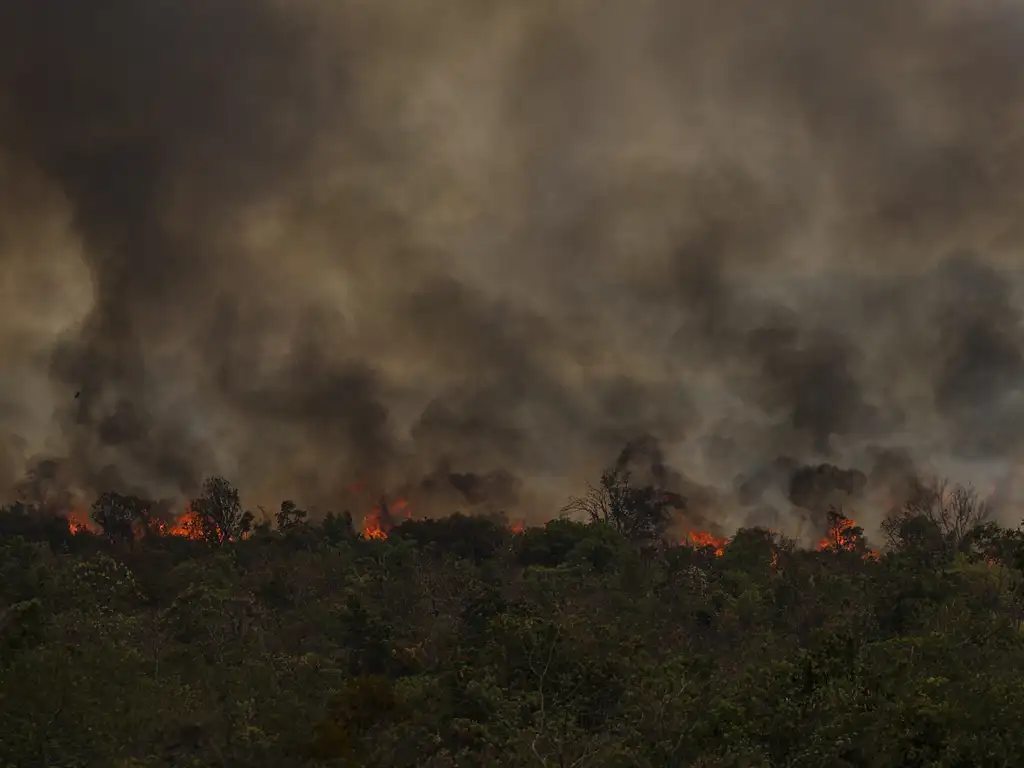
An area comparable to the state of Roraima was burned in Brazil between January and September 2024. There were 22.38 million hectares - 13.4 million hectares more than in 2023. The jump from one year to the next was 150%. More than half (51%, or 11.3 million hectares) of the area burned in the first nine months of this year is in the Amazon. The data is from the most recent MapBiomas Fire Monitor survey, released on October 11.
Approximately three out of every four hectares burned (73%) were native vegetation, mainly forest formations, which occupied 21% of the burned area. Among agricultural areas, planted pastures stood out, with 4.6 million hectares burned between January and September this year.
Mais da metade da área queimada no Brasil (56%) fica em apenas três estados: Mato Grosso, Pará e Tocantins. Sozinho, o Mato Grosso responde por 25% do total: foram 5,5 milhões de hectares queimados entre janeiro e setembro. Pará e Tocantins ficaram em segundo e terceiro lugares, com 4,6 milhões e 2,6 milhões de hectares, respectivamente. Os municípios com maiores áreas queimadas foram São Félix do Xingu (PA) e Corumbá (MS), com 1 milhão de hectares e 741 mil hectares.
>> Access the September 2024 Fire Monitor Highlights
“The dry season in the Amazon, which usually runs from June to October, has been particularly severe this year, further aggravating the fire crisis in the region - a reflection of the intensification of climate change, which ends up playing a crucial role in the spread of fires. This is reflected in the figures for September, where half of the area burned in the region was in forest formations,” says Ane Alencar, IPAM's Science Director and coordinator of MapBiomas Fogo.
So far, September has remained the peak of this year's fires. While 5.65 million hectares were burned in August, 10.65 million hectares were burned in September - a 90% jump from one month to the next. Compared to September 2023, the increase is even greater: 181%, or 6.8 million hectares more burned. The area burned in September alone corresponds to 47.6% of the entire area burned in Brazil by that month in 2024.
Repeating the pattern seen in the first nine months of this year, in September three out of every four hectares burned (75%) in Brazil were native vegetation - the majority in forest formations, which accounted for 30% of the area burned in the month. Among agricultural areas, pastures again stood out, accounting for 20% of the area burned in September 2024.
As with the total accumulated from January to last month, the states that burned the most in September were Mato Grosso with 3.1 million hectares, Pará with 2.9 million and Tocantins with 1.3 million hectares. The municipalities of São Félix do Xingu (PA), Altamira (PA) and Ourilândia do Norte (PA) had the largest areas burned: 786,000, 365,000 and 318,000 hectares.
More than half of the area burned in September is in the Amazon
A jump of 196% compared to September last year: that's what the 5.5 million hectares burned in the Amazon last month represent. This is more than half (52%) of the total burned in the period throughout the country. Half of what was burned was in forest formations (2.8 million hectares burned). Another 33% (1.8 million hectares) was pasture, which was the most burned class of anthropogenic use.
The Cerrado was the second biome most affected by fire in September, com 4,3 milhões de hectares queimados – quase metade dos 8,4 milhões de hectares consumidos pelo fogo nos primeiros nove meses do ano e um aumento de 117% em relação ao mesmo período de 2023. É a maior área queimada em um mês de setembro nos últimos cinco anos, com 64% a mais que a média histórica para o período. A maior parte das áreas queimadas (88,3%) em setembro foi em vegetação nativa: foram 3,8 milhões de hectares, com destaque para formações savânicas (2,2 milhões de hectares) e campos alagados (1,1 milhão de hectares).
“September marks the peak of the drought in the Cerrado and this makes the impact of the fire even more severe. With the vegetation extremely dry and vulnerable, the fire spreads quickly, even resulting in poor air quality in nearby towns, affecting the health of urban and rural populations,” says Vera Arruda, a researcher at IPAM and technical coordinator of the Fire Monitor.
In the Pantanal, the area burned between January and September 2024 increased by 2,306% (or + 1,479,475 hectares) compared to the average of the previous five years. 1.5 million hectares were burned in the first nine months of the year. A fifth of this total (20%) was burned in September (318,000 hectares). Last month, 92% of the area burned was native vegetation, 38% of which was concentrated in grasslands and 22% in wetlands and marshes.
Na Mata Atlântica, 896 mil hectares foram queimados entre janeiro e setembro de 2024, sendo que 71% da área afetada estava em áreas agropecuárias. Um quarto (25%) desse total foi queimado em setembro: foram 283 mil hectares – um aumento de 382% em relação à média anterior. A classe antrópica mais impactada foi a cana-de-açúcar, com 72 mil hectares queimados no mês passado.
On the other hand, due to the greater humidity observed this year in the Pampa, with above-average rainfall, the smallest burnt area of the last three years was observed for the period between January and September: 3,100 hectares.
A reduction was also observed in the Caatinga, where 151,000 hectares were burned between January and September 2024 - an 18% drop compared to the same period in 2023. More than three out of every four hectares burned (78%) were savannah formations, which indicates that fire is being used to clear deforested areas, without supervision or control of the managed area.
Since 2022, there has been a gradual reduction in burned areas in the Caatinga. It is worth noting that even with the “La Niña” or “El Niño” phenomena, the last three years of the biome have not been drought years. However, it is important to note that the month most affected by fires is October. Thus, there is still the possibility that the peak of the fires will occur this month, depending on climatic conditions and other environmental factors.