

MapBiomas' new collection, from 1985 to 2022, also shows the consolidation of two new deforestation arcs: Amacro, in the Amazon, and Matopiba, in the Cerrado
August 31, 2023 - In the last 10 years (2013 to 2022) the loss of native vegetation in Brazil has accelerated. The period coincides with the new Forest Code, approved by Congress in 2012. This is shown by an unprecedented analysis by MapBiomas based on the most recent collection of land use and land cover data, covering the period between 1985 and 2022, which is being released this Thursday (31/08). The analysis of satellite images shows that in the five years before the Forest Code was approved (2008-2012) there was a loss of 5.8 million hectares. In the five years following the approval of the code (2013-2018), the loss increased to 8 million hectares. In the last 5 years (2018-2022), it reached 12.8 million hectares, an increase of 120% compared to 2008-2012.
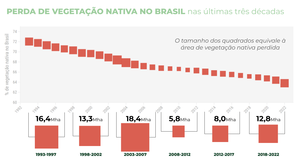
"Analyzing the annual evolution of the loss of native vegetation cover grouped into 5-year periods since 1992, when the United Nations Conference on Environment and Development was held in Rio de Janeiro, the period of greatest loss was the one just before the Forest Code was approved in 2012. But since then the loss has accelerated even more, with deforestation increasing. We are moving away from, rather than towards, the goal of protecting Brazil's native vegetation set out in the Forest Code and the commitment to zero deforestation by the end of this decade," explains Tasso Azevedo, general coordinator of MapBiomas.
The data from 1985 to 2022, in turn, show a loss of 96 million hectares of native vegetation - an area equivalent to 2.5 times Germany. The proportion of native vegetation in the territory fell from 75% to 64% in the period.
Of everything that has been anthropized in five centuries in the country, 33% has been anthropized, i.e. converted to some human use, such as cities or agricultural activities, in the last 38 years. This process has occurred most strongly in the Amazon and Cerrado, where 52 million hectares (equivalent to the area of France) and 31.9 million hectares have been anthropized in this period. In proportion to the vegetation that existed in 1985, the biomes that lost the most native vegetation by 2022 were the Cerrado (25%) and the Pampa (24%).
An assessment was also made of areas of secondary vegetation, i.e. those that have already been converted for human use and now have regenerating native vegetation. In 2022, there were more than 44 million hectares of secondary vegetation in Brazil, which represents 9% of all native vegetation in the country.
The pattern of agricultural advancement
The advance of agriculture can be seen in all Brazilian biomes between 1985 and 2022. The exception is the Atlantic Forest, the country's most deforested biome, where the two-thirds of the territory occupied by these activities has remained stable over the last two decades. In the Amazon, the area occupied by agriculture jumped from 3% to 16%; in the Pantanal, from 5% to 15%; in the Pampa, from 29% to 44%; in the Caatinga, from 33% to 40%. In the Cerrado, farming activities now occupy half of the biome (50%); in 1985, it was just over a third (34%). In Brazil as a whole, the area occupied by farming activities has gone from around a fifth (22%) to a third (33%) of Brazil. As pastagens avançaram sobre 61,4 milhões de hectares entre 1985 e 2022; a agricultura, sobre 41,9 milhões de hectares.
Satellite images show a strong relationship between the dynamics of land occupation in agriculture and livestock farming. Between 1985 and 2022, 72.7% of the 37 million hectares of growth in the area of agriculture in Brazil took place on already anthropized areas, especially pastures. Only 27.3% of the areas converted to temporary crops come from native vegetation, especially the Pampa, the border between the Amazon and the Cerrado and the Matopiba region. In the case of pasture, the situation is the opposite: more than half (55.8%) of the areas converted to pasture come from native vegetation. There were 64 million hectares of native vegetation converted to pasture. Another 5.4 million hectares (more than the state of Rio de Janeiro) were converted from native vegetation to pasture and then to agriculture. and then to agriculture.
The advance of farming took place primarily in forest areas. Of all the classes of native vegetation analyzed by MapBiomas, forests lost the most area: 58.6 million hectares were cut down in the period. If in 1985 forest formations accounted for 68% of the national territory, in 2022 this percentage fell to 58%. Next comes the savannah formation, which lost 28.9 million hectares - a drop of 22% compared to 1985.
Currently, two new arcs of deforestation stand out in centers of strong agricultural expansion: in the west of the Amazon, the border between Amazonas, Rondônia and Acre, known as Amacro, where agricultural use has increased 10-fold in the last 38 years, reaching 5.3 million hectares, equivalent to 21% of the land area; and in the northeast of the Cerrado, Matopiba, on the border between Maranhão, Tocantins, Piauí and Bahia, where farming has increased by 14 million hectares, reaching 25 million hectares by 2022, equivalent to 35% of the land area.
The new MapBiomas land cover and use dataset provides data on 29 land use classes, including beta versions of oil palm and floodplain forest areas. One of the data points that stands out the most is the advance of soybean cultivation, which has occurred in all biomes. Between 1985, this crop grew from 4.5 million hectares to 39.4 million hectares in 2022 - an area comparable to twice the size of Paraná. Soy has advanced by 3.1 million hectares in the Pampa, 18 million hectares in the Cerrado, 5.8 million hectares in the Amazon and 8 million hectares in the Atlantic Forest. In the case of the Pampa, it is changing the economic profile of the biome, which historically, like the Pantanal, has always had livestock farming on native grasslands as the main rural activity.
"The Pantanal and the Pampa are examples of biomes that are naturally suitable for livestock farming, as their fields are like natural pastures. In both cases, the advance of soy represents a degradation of the biome," warns Marcos Rosa, technical coordinator of MapBiomas.
The dynamics of occupation in the states and municipalities
The loss of native vegetation occurred in 25 of Brazil's states between 1985 and 2022. Only one state kept its area of native vegetation stable: São Paulo. Only Rio de Janeiro saw a slight increase in native vegetation (from 31% in 1985 to 32% in 2022).
The states with the highest proportion of vegetation are Amapá and Amazonas, with 95%, and Roraima, with 93%. The states with the lowest proportion of native vegetation are Sergipe (16%), Alagoas (20%) and São Paulo (21%).
The states with the highest proportion of their territory occupied by agriculture are Paraná, with 39%, and Rio Grande do Sul, with 36%. Sergipe and Alagoas, on the other hand, are the states with the highest proportions of pastureland, 62% and 52% respectively.
In 1985, 46% of Brazilian municipalities had native vegetation as their main land cover and use. In 2022, 602 municipalities left this condition and now 36% of municipalities maintain this condition. The main land use in 37% of municipalities today is agriculture.
Other highlights
Indigenous lands occupy 13% of the national territory, but contain 19% of all native vegetation in the country and only 1% of the loss of native vegetation in the last three decades has occurred in these areas.
The data on water and flooded fields in the Pantanal biome is striking. In 1985 the Pantanal had 47% water and flooded fields; in the last flood, in 2018, flooding reached 36% of the biome and, in 2022, only 12% of the biome was mapped as water and flooded fields.
What this data shows is that Brazil is a country undergoing intense territorial transformation. These changes have a significant impact on key issues such as greenhouse gas emissions and removals, biodiversity conservation and rainfall regulation.
What's new in Collection 8
MapBiomas Collection 8 features maps and annual data on the evolution of 29 land cover and land use classes in Brazil from 1985 to 2022 and also includes modules containing data on the annual evolution of deforestation, secondary vegetation, irrigation, mining and pasture vigor. Among the new features of the platform this year are the new classes of oil palm cultivation and flooded forest in the Amazon, as well as new temporal analyses, such as class stability and number of changes, of the data that make it possible to explore the transformations taking place in Brazilian territory in greater detail and depth. In Collection 8 it is also possible to carry out territorial analyses including municipalities, states, river basins, conservation units, indigenous lands and more.
>> Check out the Collection 8 fact sheet
About MapBiomas
MapBiomas is a collaborative network made up of NGOs, universities and technology companies that reveals the transformations of Brazilian territory through science, making knowledge about land use accessible in order to seek conservation and combat climate change. It has produced annual mapping of land cover and use since 1985, validates and prepares reports for each deforestation event detected in Brazil since January 2019 and monitors water surface and fire scars on a monthly basis since 1985. All MapBiomas data, maps, methods and codes are made available publicly and free of charge on the initiative's website.