

An unprecedented survey by MapBiomas shows that important hydrographic basins in the region have low forest coverage, around only 20%.
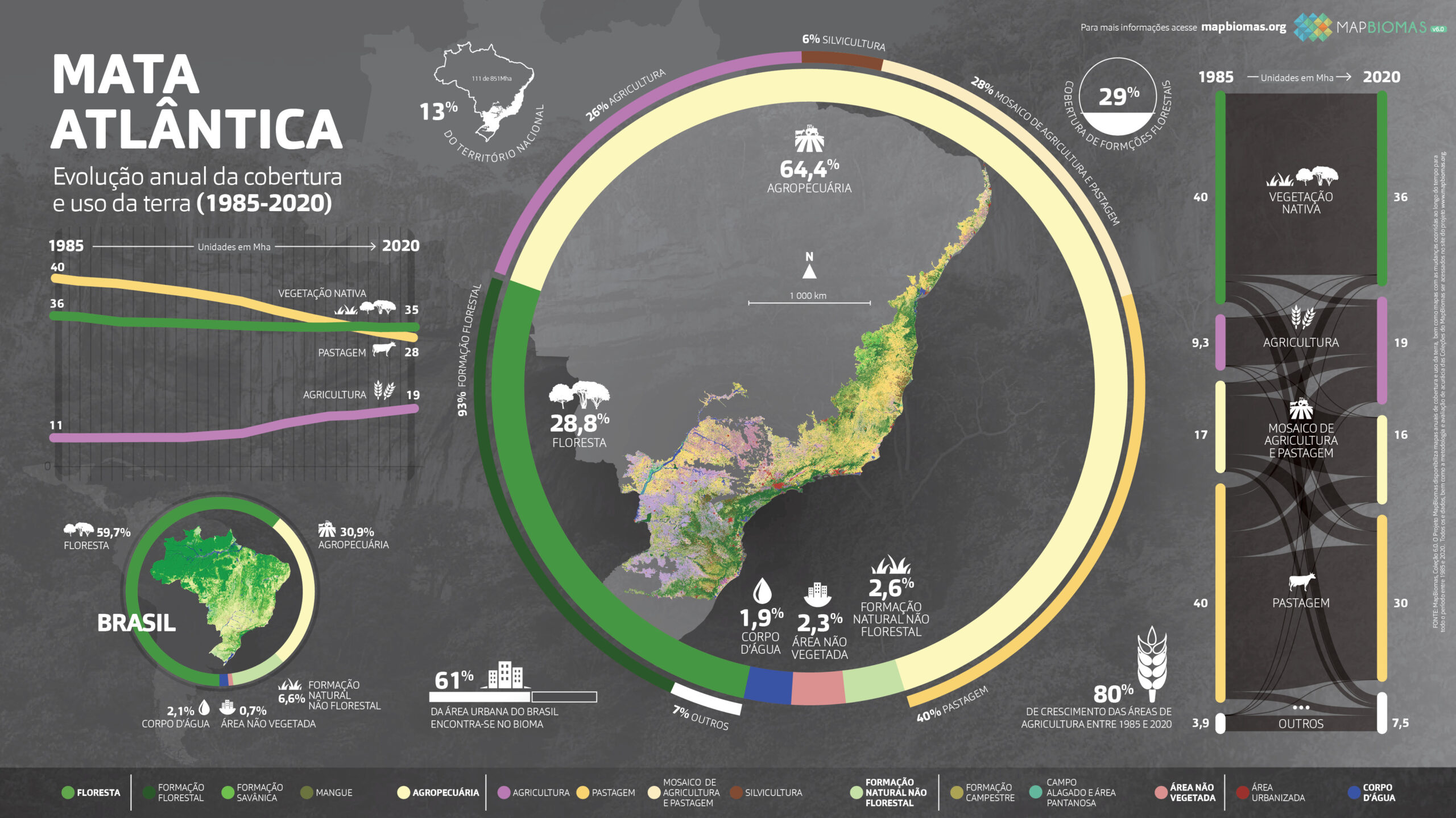
A quarter of the forest cover in the Atlantic Forest is preserved. The unprecedented data was obtained by MapBiomas from satellite image mapping between 1985 and 2020, according to the outlines determined by Law No. 11,428 of 2006, also known as the Atlantic Forest Law. As a result, all forest remnants of the biome were analyzed, including parts of Piauí and Ceará. The 465,711 km2 remaining in the Atlantic Forest are found in 17 states (the contiguous area extends over only 15 states). This and other data were disclosed in a webinar on Wednesday (15/09).
The mapping of changes in the Atlantic Forest indicates that forest cover decreased from 27.1% in 1985 to 25.8% in 2020. Currently, 25% is occupied by pastures; 16.5% by mosaics of agriculture and pastures; 15% by agriculture; 10.5% by savanna formations and other natural areas.
Forest cover has remained practically stable over the last 30 years, following a period of high deforestation between 1985 and 1990. Behind this stability, however, lies the loss of mature forests and the regeneration of young forests. Between 1985 and 2020, the loss of primary vegetation was 10 million hectares. During the same period, the area of secondary vegetation gained 9 million hectares. This loss can still be observed in certain regions of the biome, such as the Araucaria forests of Paraná and northern Minas Gerais, on the border with Bahia. The same process occurs in areas of natural grasslands, such as along the border between Santa Catarina and Rio Grande do Sul. Between 1985 and 2020, the loss of grassland formations was 28%.
"The apparent stability of the Atlantic Forest's forest cover is deceptive because there is a difference in quality between a mature forest, rich in biodiversity and carbon storage, and an area in recovery," warns Marcos Rosa, technical coordinator of MapBiomas. In addition, an area abandoned for four or five years already has a forest in an early stage, but often it is deforested, preventing this forest from recovering. "We need to interrupt this trend of destruction of mature forests and promote the maintenance of recovered forests to ensure the environmental services provided by the biome," says Luís Fernando Guedes, coordinator of the Atlantic Forest and Pantanal team at MapBiomas. In the Atlantic Forest region, more than 70% of Brazilians live, depending on the biome's environmental services to maintain air quality and water and energy supply. Encouraging the recovery of forests around rivers, spring areas, and recharge areas of urban supply systems can reduce water risk for this population.
The recovery
A portion of this process is already underway: satellite images show recovery in Permanent Preservation Areas (APPs) around rivers, mainly in the interior of São Paulo and Paraná, where pasture has been replaced by agriculture, such as sugarcane. "Pasture areas extended up to the riverbanks, promoting erosion and sedimentation of watercourses. With the switch to agriculture, the APP along the riverbanks was respected and recovered—either naturally or through native plantings. This vegetation, especially around the springs, is crucial for water quality and quantity," Marcos explains.
Nevertheless, the situation of important hydrographic basins for water supply in these states, where large urban centers are concentrated, is concerning. Many of them have low vegetation coverage, which affects water production. The Paraná basin, for instance, had its native coverage reduced from 24% in 1990 to 19% in 2020. The Rio Grande basin also experienced a slight negative fluctuation, from 21% (1990) to 20% (2020). The Tietê basin increased from 19% (1990) to 20% (2020). Paranapanema remained stable at 23% in both years. The Paraíba do Sul basin had a slight increase (from 27% in 1990 to 29% in 2020).
"The planning of forest recovery in the Atlantic Forest according to hydrographic basins is a tremendous opportunity for public managers," Marcos emphasizes. "As half of the native vegetation of the Atlantic Forest is located on private lands, policies such as Payment for Environmental Services and the creation of corridors play a strategic role in the recovery and conservation of the biome," he concludes.
Over the past 36 years, 12 states have lost native vegetation. Bahia was the champion in loss (with 9,642 km2), followed by Rio Grande do Sul (6,899 km2), Santa Catarina (6,359 km2), and Paraná (with 3,744 km2). The decade with the highest forest area recovery occurred between 2000 and 2010, when the Atlantic Forest gained 5,754 km2 of forests. For two decades, since 2000, the state of São Paulo has maintained growth in forested areas.
Check out the main highlights of the Atlantic Forest.
Download the infographic here:
Learn how the webinar presenting the data from Collection 6 of the biome went